Sunday, 24 November 2013

The Bishop and the Ballerina


[Looking over Darlington Bay, Maria Island]

The first time I got close to a bishop I was around 15 years old. Apart from his “funny hat”, I remember the meaty weight of his hands, as he laid them on my young head and intoned “Defend O Lord this thy child …”. Since then I’ve been on friendly terms with a couple of bishops. Yet until recently I had somehow avoided meeting one particularly solid Tasmanian example.
Bishop and Clerk is a mountain, or more accurately a cluster of dolerite spires, that rises 620m straight up from the Tasman Sea at the northern tip of Tasmania’s Maria Island. Its name derives from a supposed resemblance to a processing bishop and his attendant clerk. From Darlington it’s a sometimes cloud shrouded backdrop, picturesque and prominent but never intimidating. It has always struck me as an easy peak to reach. Perhaps that’s one reason for us never having met, despite my dozen or so trips to this beautiful national park. Perhaps it’s also that the island holds so many other wonders.

But sometimes the ducks line up. A long weekend; a break in the weather; a few other walkers who’d never been to the Bishop, saw a group of us wandering up towards the stony cleric.


[Looking towards Bishop and Clerk] 
 620m doesn’t sound much. After all most Tasmanian peaks worth aspiring to are double that height or more. But I should have remembered my previous experience with Mount Rugby, in Tassie’s south-west. It rises just 771m above sea level: but sea level is the crunch here. Most Tasmanian mountains are climbed from foothills that are already several hundred metres high. With Mt Rugby and, I should have realised, Bishop and Clerk, you start at sea level. You have to gain the whole of its height using leg power.


[Looking towards the Freycinet Peninsula from Maria Island] 
For much of the way Bishop and Clerk is actually a stroll, and a spectacular one at that. You amble along through open pasture, climbing gently. To the left of the track are the spectacular drop-offs of the Fossil Cliffs. To the north are distant views of the mountains of the Freycinet Peninsula. Ahead are the rocky pillars of Bishop and Clerk, oddly slow to come any closer.

The track steepens, the woodland thickens, and still no summit. Finally the familiar sight of dolerite scree offers the hint that you’re getting there. You shouldn’t get your hopes up: there are more twists and turns to this summit bid than a Stephen King thriller. As we get close to the top of the scree, one previous summiteer reckons it’s only five minutes to go. Thirty minutes later, lathered in sweat, we grunt up the last airy boulders and we’re there. And I’m immediately wondering why I haven’t got acquainted with this bishop earlier.
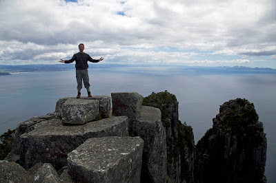


[Sermon on the mount? Mike takes in Bishop and Clerk.] 
The views are superb: vertiginous beneath us, expansive and grand in most other directions. During an early lunch on the summit, it’s hard to choose where to look; difficult too to do justice to it photographically. Forest, cliffs, sandy beaches, glittering ocean and sea birds all contend for attention.

The descent feels even steeper than the climb, especially when one of our party loses footing and tumbles and rolls for several metres. Fortunately she suffers nothing worse than bruising and a big shake-up. We travel on a little more circumspectly, giving us time to take in even more of the island’s other wonders.

Ruins from the convict and industrial eras are everywhere evident, though some are being reclaimed by the bush. Wildlife is also abundant, and often quite unconcerned by human presence. On the way back a flock of Cape Barren geese flies in and lands nearby. I watch closely, intrigued by their spectacularly unlikely colour scheme: a grey and black body offset by hot pink legs and a fluoro-lime bill.


[A Cape Barren Goose on Maria Island] 
I am amused too by their shape, the flouncing ballerina bustle accentuated by their dance-like steps; deliberate, precise, a demi-plié perhaps, followed by a turnout. The wary eyes betray the possibility of a pas de chat when frightened. The bird’s gaudiness is such a contrast to the bishop’s dark and sombre tones. Yet somehow the two typify the amazing contrasts that are Maria Island.

A part of me can’t help wondering what the bishop might say to the ballerina.

Sunday, 17 November 2013

Close to the Edge

                                              Close to the edge, down by the river. 
                                              Down at the end, round by the corner.*


[Looking towards Cape Raoul] 
I was watching them, waiting for their moment. Mine had come thirty years earlier, and the lead-up details were now hazy. But not the moment itself.

Three interstate visitors had joined us to do a quick reccie of the Cape Raoul track on the Tasman Peninsula. Each was relishing the cool, semi lush forest through which we climbed. That much was already pleasing.

An hour or so into the walk my memory jagged. Ahead I sensed a thinning of the trees, a slight rise in the breeze, a change in the sound and feel of the air. Yes, this was it. I pulled back to watch their faces. The now scrubby forest abruptly stopped, the muddy track became rock, and then … thin air. Astonishingly we had walked straight up to the edge of 400m high cliffs. Far beneath us surged the Tasman Sea.


[Far below the cliffs a cruise boat heads towards Tasman Island]
If there were audible gasps they were carried off in the breeze. But their faces said it all. Though a writer shouldn’t admit it, words do fail us sometimes. Being close to the edge can leave you speechless. In my youth I was won over by Yes’s remarkable album “Close to the Edge”. But it certainly wasn’t the florid lyrics of its title song! No, Yes was always more about expansive, mind-filling music and a general edgy, progressive vibe.

Oddly all of those descriptions worked for these remarkable cliffs. After a couple of days walking parts of the proposed Three Capes Track – a track that will eventually lead walkers around Capes Raoul, Pillar and Hauy – we still struggled to find adequate words. But there was certainly a mind expanding vibe!


[Some of the wildflowers between Fortescue Bay and Cape Hauy] 
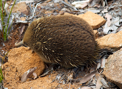
How do you encapsulate a place that not only staggers you with its cliffs – the highest sea cliffs in Australia – but also entrances you with its plethora of wild flowers? Or that enthralls you with its views of wildlife – from breaching whales, to soaring eagles; and from furtive wallabies to downright friendly echidnas? (One walked over the boot of one of our party as she stood to watch.)


[A friendly echidna pauses beside the track] 
From the grand scale right down to the minute, there always seemed to be something capturing our attention. Even the irony of having our imaginations held captive wasn’t lost on us. This peninsula was once chosen as the perfect physical site for convict-keeping. Its wild cliffs, tempestuous seas and relative inaccessibility helped ensure that Port Arthur’s captives rarely escaped.


[Crossing a stone bridge on the Cape Hauy Track] 
In the end, I think irony, perhaps paradox, reigns here. Vastness doesn’t overwhelm closeness; echidnas and wildflowers showed us that. Grandeur doesn’t overpower your sense of belonging. It seems that this is a place where you can get close to the edge and move beyond fear to something more akin to joy.

* from “Close to the Edge” by Jon Anderson and Steve Howe


Sunday, 3 November 2013

A Rite of Spring

When you live on an island that straddles the Roaring Forties, you know that spring weather is going to be “interesting”.

There are complex meteorological reasons for this, but let’s simplify. When the huge land mass to our north is warming far faster than the vast oceans that totally surround us, that differential is going to mean volatile weather. At the whim of those two geographical bullies, our spring isobars tighten, as though tensing themselves for a pounding from the wind, snow, rain and sun.


[Good weather for sitting by the hut fire] 
And so it proved again for this year’s Show Day weekend. With cold fronts and cloud bands lining up for their turn, we wisely included a hut in our “boys’” Cradle Mountain bushwalking plans. It’s not that we object to a bit of whooshing weather; we know it helps make the place what it is. It’s more that we enjoy retreating to a hut after we’ve braved those elements: somewhere to warm up, dry off, sag down, have a few drinks. The perfect setting to remind ourselves how courageous and adventurous we’ve been going into the mountains in such conditions!

That was the theory at least, and it fed our email banter in the days before the trip. As we drove into Cradle Valley it was snowing and blowing, and the short walk to the hut was through six inch deep snow. But we dismissed the scene as merely “atmospheric”, especially when the wood heater was cranked up, and the first wine and cheese were liberated.

Ah but there’s always cabin fever. Reading, eating, snoozing, talking are all very well, but they need to be broken up by a little physical activity. And somehow the “12 Minute Indoor Physical Fitness” program that Tim O had thoughtfully printed out for us was never going to be a total success. No … come Saturday we were well and truly ready for some actual bushwalking.

When the weather was looking vaguely less threatening, Tim D suggested a 2 to 2 1/2 hour walk via some seldom-walked tracks and routes that he knew. With naïve trust in our friend, and a “what-could-possibly-go-wrong?” attitude, we kitted up and headed off.


[What lay ahead for us on the Cradle Plateau] 
The plan was to climb up to Cradle Plateau gradually – a kind of long sneak attack by way of Riggs Pass – before looping back towards the hut via the Horse Track. We’d be back for lunch.

Two hours later the fun really began – and we weren’t even on the plateau yet. We’d left a well-marked but unmaintained track and joined an occasionally-marked but overgrown route. As we climbed higher, tripping and slipping through ankle-tapping scrub, the weather wavered a little. Was it going to offer us some views or would the rain and snow grow worse? Frankly we expected both.

We weren’t disappointed, although it wasn’t until we reached the highest parts that the snow and wind really kicked in. Horizontal snow and sleet lashed us, biting into the exposed parts of our faces, relenting only when we found rock outcrops to shelter behind. Yet any stop quickly chilled us, regardless of the quality of our wet/cold weather gear.


[A chilly stop on the Cradle Plateau] 
We walked on, despite the Antarctic conditions, finally cresting the plateau. Visibility was poor, route markers very sparse. Tim D tried to look confident – and occasionally failed – as he searched for the cryptic route. It should be intersecting with the Horse Track, a well-marked alternative section of the highway-like Overland Track, somewhere up ahead.

Nearly four hours after starting our walk, we at last spotted the markers of the Horse Track. A couple of us whooped; Tim D looked relieved. A surprisingly high cornice of snow separated us from the track, so in a close simulation of youthful exuberance, we body-tobogganed our way down to the track.


[The Horse Track at last, with Crater Peak behind] 
An hour later we were back in our warm hut and pouring some wine. But then, as if to make us question what the fuss and fear had been about, two things happened simultaneously. The sun shone, and a wedding party turned up at our hut for a photo shoot. All dressed in the usual gear, they had made only one concession to the conditions. The bride wore floral gumboots. Ah spring!


[And the bride wore gumboots!]